Image Resource Bank
Image Gallery |  12 of 15
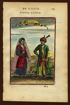
Mallet’s “Persians”
By the middle of the sixteenth century, British and French diplomatic and trade missions sought contacts with realms of the East, among them Safavid kingdom of Iran. Some European states, like Britain and France, had common economic interests with Iran, on the basis of growing worldwide trade. Others, like the Habsburgs of Austria and the Holy Roman Empire, had common political interests, on the basis of shared enmity with the Ottomans. Interests of these kinds promoted realistic views of Persians and other Middle Easterners, views that might portray them as exotic, but without contempt, even with envy, treating them as citizens of a world of work, trade, war, arts, and letters that was shared with Europe.
This image of Persians comes from the encyclopedic Description de l’Univers by the French engineer and cartographer Alain Manesson Mallet. It shows representative Persian features and dress against a representative landscape and vegetation, unifying social and geographical information in much the same way as the earlier Map of Cairo shown in image #11.
![]() Double Portrait of Sir Robert Shirley in Persian Dress and His Wife Teresia in European Dress
Double Portrait of Sir Robert Shirley in Persian Dress and His Wife Teresia in European Dress
Name: Mallet’s Persians
Material: Paper, ink
Size: Unknown
Date: 1683 CE
Place of Origin: Description de l’Univers,
Alain Manesson Mallet
Location: Description de l’Univers, Alain Manesson Mallet
Source and Registration#: Columbia University. Link to resource![]() (accessed March 18, 2010).
(accessed March 18, 2010).

 Matthew W. Stolper
Professor of Assyriology and the John A. Wilson Professor of Oriental Studies


